Flat earth: Are Australia to South America flights real?
Air New Zealand now flies direct to Buenos Aires from Auckland. The flight time is approximately 12 hours. They operate three return services a week with their Boeing 777-200 airplanes all year around.

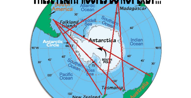
Many believers in the flat earth claim such flights are impossible and not real. This is because most flat earthers accept a map that puts Australia and South America on opposite sides of their flat earth making them so far apart that you would have to travel at more than twice the speed of sound to make the journey in the twelve hours that these flights actually take to transport passengers from Auckland, New Zealand to Buenos Aires, Argentina.
So just to find out for myself if these flights are real or not I booked a return ticket to Buenos Aires in December 2017.
I left Auckland on the evening of December 11, 2017 and did arrive in Buenos Aires approximately 12 hours later, along with a full plane load of other people. I also took the return flight from Buenos Aires to Auckland on December 24, 2017 and that similarly took about 12 hours and I most certainly arrived in Auckland.
To try and understand exactly where the plane was flying I took my iPhone with a data logger logging all the sensor information it could get for the flight. Unfortunately on the flight to Buenos Aires, perhaps to the design of the airplane, the iPhone could not pick up any GPS signal but on the return flight it was a different plane and I was able to get GPS coordinates for at least part of the flight. But the other senses like direction, altitude, speed, etc, were working an logging data on both flights.
I am including the raw datalogs for both flights below and please analyze them yourself and let me know what you find in the comments:
AUK-BA_2017-12-11_21-23-39_+1300
BA_AUK_2017-12-24_23-48-23_-0300
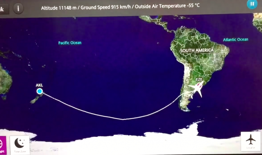
Please see the image below for the GPS data I was able to collect on the flight from Buenos Aires to New Zealand. It is incomplete but these are actual GPS coordinates recorded and logged by my iPhone on the flight. So it appears they have taken the long route. As we are lead to believe that if they would have flown down towards the South Pole, because the earth is a globe, it would be shorter. But instead of doing this they have flown up, towards the equator, then back down again towards New Zealand. So the route according to the GPS coordinates does appear a bit different to the route they show on their flight information system.
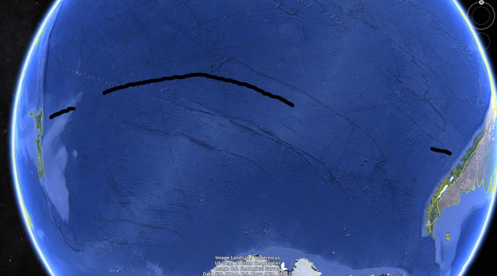
So the actual route appears to be quite dramatically different from the route they show us on the flight information screen:
So the conclusion is the flights in the Southern Hemisphere like the one I personally went on from Auckland to Buenos Aires do exist and are real and do take approximately 12 hours which would be impossible on the flat earth map unless the planes were flying at more than twice the speed of sound. Which I think we can be quite sure they are not. And we have verified they do fly on more-or-less the same route as they are claimed to fly on. So this information would appear to cast rather serious doubts on the validity of the accepted flat earth map.
Hey there, I read through your post here and found the flight pattern to be very intriguing. After a little searching, I found that the most reasonable explanation for the alteration in advertised versus actual flight path would be the local jet stream patterns at the time of your flight. If you go to this link below, you’ll find that the flight path recorded by your GPS tracker falls in line with the average jet stream pattern that would allow for minimal fuel burn. Good post!
https://www.netweather.tv/charts-and-data/global-jetstream#2018/07/20/1800Z/jetstream/surface/level/overlay=jetstream/orthographic=-129.84,-49.27,712
And the return flights are scheduled when the jet stream reverses direction.
You are comparing data from two different map types, which is not a good start if you want to de-bunk flat-earthers.
The in-flight map is not to scale and is for reference only. This is a typical false/flat map of the earth. If you took the “flat-earth” inflight map and wrapped it around a globe, you would get the same path as you’ve seen in your “globe-earth” view as shown in your image from Google Earth. Try it out and see for yourself!
P.S. Whilst the Jet Stream moves around, it does not 180degree change directions. This is why the return flights going against the Jet Stream take longer.
Pt br, Friend and if you use the UN Azimuth Map template and trace the same route? Perhaps it makes more sense, if the planes fly in the UN azimuth map model (for reference only), the trajectory would be more explained by the flat navigation and the route in question has an acceleration of 300 km hour to more site the speed of the airplane in some parts saving fuel and time. Do this research and share, thank you!
Yes. Of course that is the main point. It would be impossible to fly this route in the 10 hours or so that it actually takes if the earth was actually as it is depicted on the Azimuth map. Look at that map yourself. That map puts Australia and South America on opposite sides. So shortest distance would be to fly over the North Pole… So it is absolutely not possible to fly from New Zealand to Argentina in 10 hours on the AE map…
the azimuth projection is not a flat earth map and doesnt claim to be, its a 2d model of the globe. It is misused by people often enough that they think its supposed to be a FE model… but its not.
Be great if a flat earther put up the flat Earth map they propose is what think.
Will be easier to show and see than a globe been that it would be a 2D map of their proposed 2D earth
Any with an exponential measurement system from a nil “north pole” out is laughable
So, do they have a map were a km is actually a km?
On a globe, even though longitude lines all end at a single theoretical point, a km is still a km
Japan is approx same length and area as New Zealand, but every FE map I’ve seen shows it looking under half the lengthand area…. laughable.
Would be great if globes included all the land masses, or even the correct land mass sizes as Antarctica is a complete fiction.
and one another question
can somebody with his personal jet flight at these airways?
I don’t have a personal jet unfortunately, but I am sure someone who had a personal jet could fly on the same route that Air New Zealand does.
Yes. No problem
I used to fly business jets in the 90’s. I was lucky enough to be asked by a good friend, about 8 years ago, to fly in the jump seat from Argentina, just inside the 75th parallel, and landed in New Zealand!! It was so beautiful. At the time it was the ultra long-range Gulfstream, brand new. Total flight time…..about 15 plus hours. Piece of cake for this Gulfstream. Trust me…..this whole “FLAT EARTH” shit…..well, it is just that, COMPLETE BULLSHIT. With respect.
you say they are dramatically different, but you didn’t mention the fact that the second map IS a FLAT map. if you were to modify it too fit the globe, the difference wouldn’t be so great. it would probably still be different, but not so much.
otherwise, good job. I enjoyed the read.
You need one of those curved monitors.
Reading through your article was very interesting, as I live in New Zealand, done many overseas flights commercially, but also have some understanding through flight training as a pilot.
FEers will go on about why not fly directly over the South Pole, which in reality would only be “logical” if flying directly from a Western Australian city (Perth), to a South American city. Even Sydney to any Western South American city say in Chile or Peru if in a perfect straight line (as on a map) would barely touch the edge of the Antarctic continent, even from Africa to Eastern Australia goes no where near the Antarctic land mass. The only other “direct” flight that would pass over the South Pole would be from Africa to New Zealand, but as there are only 4.5 million here (in NZ), those direct flights don’t exist SIMPLY because they would run at a loss to the airlines. So they collect and drop passengers at either Australia, or S.A if going the other way. Madhudvisa mentioned air streams, YES! (please FEers read and take this info into high consideration…. if possible for you?), for anyone interested, have a look at this interactive map (below). Now… please all think logically, would you fly the plane against the wind, therefore using more fuel and taking longer, or divert and fly with the direction of the stream? I hear read this blab by FEers is no diff to crashing in the sea, compared to Antarctic, um yes there is… Do some research into shipping, sure both most likely would disastrous, but rescue is more probable anywhere oceanic, compared to mid Antarctic which is a MASSIVE continent. I would rather take odds of ditching in the Southern ocean and been in a lifeboat for a few days.
https://earth.nullschool.net/?fbclid=IwAR3eAml0C_qWwNElX13GFl1MyzdLbGDFKR5jYIP7mLqdr5u-P0WeuKb7OfM#current/wind/surface/level/orthographic=55.68,276.50,284
I have flown too Europe to australia quite a lot, and can tel you went no where near the arctic as would be the fastest route on a airplaine. I dont really think there are many people that are acutally flat earthers just people that like to be contary, and those who like the mental challenge of trying to make it fit the observed facts, PS i remember watching live sporting events in the northern hemishpere live at the same local time as where i live in the southern hemisphere
See also …
http://www.gcmap.com/featured/20190320
Hi there,
If you look at the well known flat earth map (im not saying that i think it is correct) the route from auckland to Buenos Aries direct flight would go over the ocean and not any land. So i would say this does not disprove the flat earth model at all
See link to generic flat map https://www.livescience.com/63648-flat-earth-explanation-for-the-equinox.html
Let me know thoughts
G
The problem is the time it takes, on flat earth map it is very, very far, one side of the flat earth to the other, would take 24 hours or so, but flight only actually takes 8 hours…
The difference in the routes is easily explained because both maps use a different projection method. Both curves are a straight line on a 3-dimensional globe.
Exactly this!
They are precisely the same routes, only the one on the in-flight system is projected on the Mercator projection, making it look like a detour through the South! This is not the case, both your GPS data and the in-flight system are almost a straight line from NZ to Argentina.
Yes. My practical experience in flying from Australia to Argentina in 10 hours in more-or-less a straight line is certainly in accordance with what we would expect on a globe earth, and is totally impossible on the flat earth map…
If it was flat I could see Mount Everest from Anywhere on Earth based on its height and altitude from sea level and if Sun was moving while earth stationary as flat theorists suggest then Moon will not have phases of light
H g Dave – you know when you watch the weather report and there’s that bit that tells you what ‘visibillity’ is like for the day? That’s because of atomspherics, the same reason you cant see everest.
No you couldnt. Nor am i a flat earther. But i have seen ships using scopes that are 20+ miles out at sea and that is impossible on a globe model.
20 plus miles Bob? That’s only 35km.
Why is that “impossible” on a globe?
From my back lawn Solander Island (south of New Zealand) is visible on the horizon, from me to it is 79km due Southwest
BUT, it’s only visible because Solander Island is small and over 330 metres high (1000 ft).
Regarding weather and light.
On the clearest day it’s sometimes barely able to be made out, but on that same day at dusk when there’s concentrated light coming on the Island from the right (West), Solander sticks out like a bashed thumb
Does this prove/disprove globe vs FE ? No. It’s just observations
In regard to FE, no flat earther’s have answered my questions in comments below, why not?
The fact that their flat earth maps are all based on an exponential measuring scale.
Which on their maps makes the length of Japan minuscule compared to the length of NZ, but the two country’s are basically the same size.
Would it be impossible if 40 miles out?
Hi Bob
So you got me thinking, be it a VERY LATE response but oh well here goes.
Note – I did not complete this exercise to “prove” Flat Earth or “disprove” it, was an exercise in “well now i damn well want to actually know.
Anyone can search and find close up aerial photos of Solander Island, note that it has a central higher spiked “peak”
Solander is 333 metres high (1000 foot). With my cellphone on full zoom FROM SEA LEVEL I have taken quite a few photos of the ENTIRE Island, bulky party and quite obvious central “peak”. Through my old binoculars I could see the outer rocks and mist from crashing waves.
SO – It did NOT matter which online global curvature calculator I used, I tried a few to not only double check but triple check and… four check.
But, the math is the math, and when (allegedly) does math lie?
My address – 5 Bluecliffs Beach Road Papatotara. Put that into Google Earth select the measure tool and you will see Solander is 70km away on a 231 degree heading
The curvature calculator –
h0 – Eye Height……………….. 2 metre
d0 – Target Distance………… 70 km
d1 – Horizon Distance……….5.04 km
h1 – Target Hidden Height…..331.08 <——– 331.008 metres?????????
BUT SOLANDER ISLAND IS ONLY 333 METRES HIGH…..GET IT? By their curvature calculator I SHOULD ONLY BE ABLE TO SEE IT'S TOP 2 METRES.
NO WAY, on a clear Sunset the entire Island was quite visible and I have many photo's to show that. Through my binoculars or on cellphone 4x zoom I could see the Westerly and Easterly rocky outcrops.
OK OK OK… All the Flat Earther's are going "Haa..! See… Proof" and all the Globies are humming & haring and now going to go and try disprove the above.
If could post pics here I would – Most evenings we would be down the garden and watch the sunsets, they were usually always stunning as the sun dropped down behind the bottom of Fiordland.
Smell the sea and feel the sky
Let your soul and spirit fly.
NOT A FE BUT LOOKING FOR ANSWERS:
It’s so sad to see FE not celebrating at this, and it’s proof that unfortunately most of the FE community doesn’t understand much about math. Anyway to any careful observer: This is indeed one of the best proof of a flat earth.
If you take a “globe map” and measure the distance between Buenos Aires and Auckland, then take the same globe and measure the distance between London and New York, and then you proceed to also take the average flight time for direct flights on these trajectories (7.5 hours in air), then you also consider the jet streams (that anyway can be “fully used” only at times, you can check this watching at the world record for civilian London – New York flights which has been scheduled on purpose by the British Airlines on a specific date to fully use the jet streams of that time bringing the flight duration down to 5 hours) and the average transoceanic flights speed (between 0.65 and 0.85 mach), you can conclude that on a globe a direct flight from Buenos Aires to Auckland should take much more (from 2 to 3 hours more depending on the airplane real speed and time of the year), while the flight time on a flat plane would correctly match what you have observed.
This raises some questions, at least for me, if anyone would be willing/able to elaborate more on this, I would be very happy to listen to any explanation about it, because honestly I may be missing something, but this definitely scores in favor of the flat earth model.
Hi Soul
The Southern Hemisphere flights are real and the flight times are consistent with a globe earth and impossible on the map given to us by the flat earth people. So that proves at least the flat earth map is completely wrong.
What no Flat Earth believer will approach or debate, is the problem that their “map” is based on an exponential measurement system.
Their kilometre is a millimetre long at their “north pole” and exponentially becomes about 5 kilomtres long their outside “Antarctica rim”.
Their “map” shows New Zealand to be 4 or 5 times longer than what it is. But, as I’ve driven it numerous times, The South Island is abput 1100 km long and I’ve driven it in 13 hours.
Just as I’ve driven 1100 km up the UK, in same time frame.
Secondly in regard to there “but no flights go across Antarctica” globe map of the South Pole. Maybe they could get on Google and research The Rhumb lines?
Then they’ll reaslise that that is one reason very few flights go over the South Pole, but the other is safety, simply look at the immense distances of empty ocean and no civilisation when viewing the South Pole compared to the North.
No airline company wants one of their flights on trouble down there, virtually nil chance of survival.
Flat Earth followers need to look at what they propose as the “reality” with logic, practicality and the application of basic math
Hi Ted
Yes. You are correct of course. This is not really a site for globe earthers to fight with flat earthers. We are trying for something different. We are trying to find out what is the truth actually about the structure of the solar system, etc.
The “Flat Earth Map,” it is not a flat earth map actually and you are correct, Southern Hemisphere, it is not drawn to scale as far as the sizes of the land masses. It was not made as a flat earth map, and it was never intended to be an accurate depiction of the world as it is. It is for navigation.
The beauty of the “flat earth map” is you can draw lines on it from where you are to where you want to go and measure the compass direction and head in that direction and you will get there. So if you want to go from Los Angeles to Auckland, on the flat earth map you can just plot your course and measure the angle and head in that direction and you will arrive in Auckland. That is what the “Flat Earth Map” is really for, a navigational aid. It is a depiction of a globe, like all other flat maps, it is a projection of a globe on a flat piece of paper. So this particular projection, yes, it distorts the sizes of New Zealand, etc, but it keeps the directions accurate for navigation.
Still you have diverted fron the points i have raised.
Regardless of the 2D projection that a flat earth map uses, if to scale or not, the flat earth map still uses an exponential measurement system..!
We know the time frames to fly between 2 points across the southern hemisphere, going by any flat eath map that same distance would take a tenth the time (or less) in their “northern” hemisphere.
Yes. I agree with you Ted. Flat earth map does not work at all.
“Unfortunately on the flight to Buenos Aires, perhaps to the design of the airplane, the iPhone could not pick up any GPS signal but on the return flight it was a different plane and I was able to get GPS coordinates for at least part of the flight. But the other senses like direction, altitude, speed, etc, were working an logging data on both flights.”
Most flights avoid going to far over open ocean, but here it appears GPS fails through significant parts of both your flights. It seems much more consistent with terrestrial hyperbolic radio navigation.
On The Level. You miss the point totally. The flight took 10-11 hours. Consistent with the globe earth model, but impossible on your flat earth map. That is the point. This is 100% proof that your flat earth map is incorrect. That’s all.
As far as the satellites, most flights these-days, they have satellite internet. Everywhere. All over the planet. So that is not possible from ground-based stations.
Anyhow the point of this article is that the reality is consistient with what is predicted by the globe earth model but impossible on your flat earth map. So this is 100% proof that the so-called flat earth map is incorrect. Because on that New Zealand and Argentina are on totally opposite sides of your map. You’d have to cross the NORTH pole to make this trip on a flat earth. And you can’t do that in 10-11 hours…
$On The Level. You miss the point totally. The flight took 10-11 hours. Consistent with the globe earth model, but impossible on your flat earth map. That is the point. This is 100% proof that your flat earth map is incorrect. That’s all.”
Be honest. I don’t have a Flat Earth map, as I’ve mentioned all the maps have problems and so do the globes. Your flight was 12-13 hours not 10-11. Just saying keep it real.
Have a great day!
OK, you don’t have a map. That’s the problem. You have an idea “The earth is flat.” But you can not even draw a map that is consistent with our actual physical experience and observations presuming the earth is flat.
However, we can plot our experienced observations on a globe and it works quite well.
So here, we have got confirmation that the globe model is at least possible and it is consistent with our observations.
But you can not understand how the earth could be flat, you can not imagine a map that would work if the earth was flat, you can not explain what we see happening in the sky if the earth was flat.
So you are not logical, your presentation has no basis, you don’t even have a model, you don’t have a theory, you have this idea, “earth is flat” but you have no way of explaining how it could be flat, no understanding of how it could work if it was flat. So it is pointless talking about it to the scientifically minded who need a logical explanation.
You are not a logical person, your belief in the flat earth is sentimental only. It is pointless to say all these crazy things. It is more or less insanity.
“You are not a logical person, your belief in the flat earth is sentimental only. It is pointless to say all these crazy things. It is more or less insanity.”
You’re projecting. You’re the one who cannot explain why there’s no 24 hour sun overhead in the southern extremities but has been seen in the Arctic regions numerous times. Why video attempts to show a 24 hour sun in Antarctica have been disproven. Why you’re own posted video from the southern tip of South America was cut is left unexplained, apparently the narrator is supposed to tell you what you see rather than it being self evident.
Further, why the two supposed hemisphere are completely dissimilar climactically, in distribution of lands and electro-magnetically. You can’t even explain how a magnetic compass works at the equator.
You can’t explain why maps and globes after 1540 fail to show known land masses displayed, attested to and acknowledged prior to that time. You can’t even explain why or how the presumed satellites and international fake station stay aloft or can reside in the region they do at the temperatures supposedly measured for the region. Your attempt to explain NASA’s clear recorded actions to fake travel on the international fake station was funny and lamentable. Your attempt to explain why many companies manufacture hyperbolic radio navigation devices that exactly mirror supposed satellite GPS was just to parrot the claim they’re used as back-up. If so why is there an entire private industry of outside parties investing in them?
You can’t explain how if the globe has the 25k mile circumference claimed we can see, visibility permitting, much farther than 3 miles standing on the shore ( tens of miles ). You failed to look at those southern skies and explain why so many people claim that several Southern constellations like the Southern crux cannot be seen everywhere South of the equator, but all northern constellations can be seen north of the equator! You express great faith in degrees latitude such that Polaris supposedly falls below the horizon at the equator, but then have to admit it can be seen south of the equator. Your own post listing observations from over 20 degrees south of the equator. Bizarrely, you blame it on refraction. This despite the fact you acknowledged the Earth’s supposed tilt was dreamed up to account for those very observations.
Finally, I could go on but leave it to say the main points of a flat earth map including the southern ICE-WALL extremity, sun & moon circling over a flat earth and a north polar electro-magnet drawing directional lines to all points on the Earth I accept and follow from observation.
If you erroneously deny what I claim explain how a magnetic compass can find away to point to the North Pole at the equator.
Good luck.
Have a great day!
P.S. I’ll take it that if this post does not appear, that you are as you say likely illogical, “crazy” and would you say insane.
Hi On the Level. I do not believe that the earth is flat or that the earth is a spinning globe in space. I am open to any possibility and I do strongly suspect that our current understanding of the earth as a globe spinning in space is not correct, at least not a complete understand of the system as it is actually working.
However finding small faults or discrepancies in the globe earth model, which I do agree exist, does not prove that the earth is flat.
I am point out that it is not logical to believe something which you can not explain. So that is your position. You believe the earth is flat but can not explain how the earth could be flat. You already stated you have no map and no idea how a map could be drawn if the earth is flat.
You point out that all maps have discrepancies. And yes. Everyone knows that it is not possible to draw a map of the surface of a globe on a flat piece of paper without distorting the shapes and sizes of the continents and/or the distances between them. That is give. All flat maps will have distortions because they are projections of a globe onto a flat plane.
But if you draw the continents on a globe then you can draw them in their actual correct sizes and shapes and have the correct distances between them with no distortion and no difference between the presentation on the globe and our practical experience.
So that is certainly a point in favor of the globe earth model and a point against the flat earth model. That no flat map can accurately represent the shapes / sizes and distances of the continents but they can be accurately represented on a globe…
As far as the missing land, let us know exactly where it is, and we can look for it. We do actually have satellite imagery of almost all of the planet.
Even if the satellites are balloons as you say. Somehow they have got something up there, at least in low earth orbit, orbiting the earth and taking photos. That is certainly verifiable and if you don’t believe that you are certainly not very bright, or just denying the reality because it disagrees with your religion.
I live south of the equator, in Australia, and often look up at the sky at night. And whenever I look in the sky the southern cross not always there. It moves around, it circles the southern celestial pole. So depending on where you are exactly at times it could be below the horizon. Depending on how far south you are. You have to understand that in the Southern Hemisphere we are not so far south as people are in the northern hemisphere. Sydney, for example, is only 33 degrees south. So from there the southern celestial pole has only moved up 33 degrees in the sky above the equator. So we do not see all the southern constellations at the same time. The southern celestial pole is always there, same spot, 33 degrees above the horizon. So sometimes part of the southern cross will be below the horizon in Sydney.
Southern Cross will always be above the horizon from 35 degrees south to 90 degrees south [South Pole]. But from 0 degrees south [the equator] to 35 degrees south the southern cross will be either partially or completely below the horizon at times.
The same thing is happening in the northern sky. That is why I say “Flat earthers don’t look at the sky.” And you are proving me correct. Because it is the same in the Northern hemisphere. As you move closer to the equator the polestar drops down closer to the horizon and so more of the northern stars become sometimes below the horizon.
So what is happening in the northern and southern skies is identical.
As far as seeing in the distance, yes, as far as I can tell that is a real issue, in certain circumstances we can see a lot further than we should be able to see on a globe. I do not believe in the globe, necessarily, but I do not rule out the possibility that we are on a spinning globe either.
As I said searching for small inconsistencies in the globe earth model does not prove the earth is flat. If you want to say the earth is flat, then you have to be able to explain how the earth could be flat and produce the physical observations we experience. You need a flat earth model that works as well as the globe earth model. Otherwise it is illogical. Logic requires that you should be able to explain your beliefs in some sort of reasonable way. There is currently no reasonable way to logically explain how the earth could be flat. So it is illogical.
That does not, however, mean it is not flat, but what it means is we can not imagine how it could be flat and at the same time we could experience the things we experience. So you have to explain it. That is the positive thing, you have to explain how it could work if the earth was flat, not just try to find faults in the globe model. Because finding faults in the globe model does not prove the earth is flat.
Just a request. Can you explain why it takes 12-13 hours for a Boeing 777-200 to travel 5-6000 miles at a flight speed of about 650 miles per hour?
Your so logical and all. Thought you might know!
Flying non-stop from Auckland to Buenos Aires:
Flight distance: 6,448 miles or 10377 km
Flight time: 13 hours, 24 minutes
So my flights were a bit shorter than this. But.
6500 miles in 12 hours lets say: 6500 / 12 = 542 MPH.
But you know it is not flying always 650 MPH. It is much slower on takeoff, and when it is getting up to cruising height, and landing, and they always go slower for better fuel economy and to give them the ability to make up lost time if they are running late.
So they could do it quicker than what they actually do, but they go slower for these 2 reasons, to save fuel and to give them the ability to meet their schedules even if, say, the takeoff is delayed, they can fly a bit faster and still land at the scheduled time.
“As far as the missing land, let us know exactly where it is, and we can look for it. We do actually have satellite imagery of almost all of the planet.”
Wrongo! you have high altitude photographs of small regions of Earth spliced together into a composite image of a larger region. Those images are simply the ones they allow you to see. You have no idea how much of the Earth you are viewing. These images are unlikely taken from above the Karman line 100km up, defined in the 1940’s as the lowest region of outer space. It’s becoming fashionable to now to call the lower Mesosphere/layer outer space. Branson claimed to have gone to space recently, but was infact in the Mesosphere/plane. He never made it that high, nor has any so called “satellite” or high altitude platform, they are likely all below 100km.
“I live south of the equator, in Australia, and often look up at the sky at night. And whenever I look in the sky the southern cross not always there. It moves around, it circles the southern celestial pole. So depending on where you are exactly at times it could be below the horizon. Depending on how far south you are. You have to understand that in the Southern Hemisphere we are not so far south as people are in the northern hemisphere. Sydney, for example, is only 33 degrees south. So from there the southern celestial pole has only moved up 33 degrees in the sky above the equator. So we do not see all the southern constellations at the same time. The southern celestial pole is always there, same spot, 33 degrees above the horizon. So sometimes part of the southern cross will be below the horizon in Sydney.
Southern Cross will always be above the horizon from 35 degrees south to 90 degrees south [South Pole]. But from 0 degrees south [the equator] to 35 degrees south the southern cross will be either partially or completely below the horizon at times.
The same thing is happening in the northern sky. That is why I say “Flat earthers don’t look at the sky.” And you are proving me correct. Because it is the same in the Northern hemisphere. As you move closer to the equator the polestar drops down closer to the horizon and so more of the northern stars become sometimes below the horizon.
So what is happening in the northern and southern skies is identical.”
You should in time be able to see the Southern crux and any other constellations from any southern equatorial position as the star system rotates. This is seen all the time in the North with Virgo and other constellations, that can be revealed with time-lapse photo-imaging. From what I’ve read this cannot be done South of the equator for several Southern constellations. My travels south have been limited. please tell me what you experience. Thanks.
Hi On the Level.
It is the same as the North, the sky here, it behaves exactly the same except we don’t have an actual star at the central point where everything rotates around.
And it is the same with southern cross, if you are below the 35 degree mark, closer to the equator, at times part or all of the southern cross may be below the horizon, but yes, if you wait it will rotate around the southern celestial pole and you will see it.
So south and north celestial poles act exactly the same way, and in a way consistent with what we would expect to see from a globe spinning in space.
Now, possibly we may not be on a globe spinning in space, but it is certainly a very valid assumption to presume it is very likely we are on a globe spinning in space because what we see happening in the sky, it really quite strongly suggests that we are on a globe spinning in space.
If you are going to convince us we are on a flat plane then you have to give some model that would enable this manifestation in the sky from a flat plane. So far that is missing from the flat earth people.
“But you know it is not flying always 650 MPH. It is much slower on takeoff, and when it is getting up to cruising height, and landing, and they always go slower for better fuel economy and to give them the ability to make up lost time if they are running late.
So they could do it quicker than what they actually do, but they go slower for these 2 reasons, to save fuel and to give them the ability to meet their schedules even if, say, the takeoff is delayed, they can fly a bit faster and still land at the scheduled time.”
There exist two jet streams pilots can use to save fuel en-route between Aukland and Buenos Aires or visa versa. One is closer to the equator ( which may help to explain your observed flight diversion ) and the other farther south in the opposite direction. Jet streams can add hundreds of miles per hour to clocked air speed as observed from land.
Yes, of course, and sometimes there are headwinds also that slow them down. Point is they have to fly to a schedule. They have to take off at a certain time and land at a certain time, so they go slower generally to save fuel and to give them the ability to meet the schedule and still land at the correct time if there are delays taking off, for example.
So the point is the observed times for these Auckland – Buneos Aires flights, which I have personally experienced and documented with so much data logged by my iphone sensors, even GPS signal is not always there, all the other sensor readings and timestamps are there, the point is these observations are completely in line with what we would expect to experience on a globe earth, but totally impossible on the generally presented flat earth map that puts these two cities on the opposite sides of the North Pole.
On the flat earth, to do this trip you would have to fly from Auckland up and over the North Pole for shortest route and that would be like 30,000 miles or something… Not possible in 12 hours.
That is my point.
These flights prove the flat earth map is totally incorrect, impossible, and they are inline with what we would expect to experience on a globe.
Just a post to examine the claim Eric Dubay made that globalists tilt the Earth to explain how we can see polar stars beyond the equator. In fact, tilting the Earth does no such thing. Tilting the globe Earth supposedly changes Earth’s relation to the sun, not the stars. Earth is supposedly fixed to Polaris and by extension the rest of the rotating Star Field. Please think about that. It’s supposed to explain the seasons not star maps.
This is a big problem for globalists. Why? It means we should not be able to see either Polaris south of or Southern Crux north of the equator due Earth’s presumed convex ball shape. In fact, an astronomy website of the globalist ilk provides photographic evidence the Southern Crux can be seen 25 degrees north of the equator ( even more than Earth’s presumed tilt ) in Hawaii!!! They claim it can be seen at varying times there throughout the year!
https://earthsky.org/sky-archive/southern-cross-visible-in-hawaii-before-sunrise/
Globalists have provided no explanation for this, even refraction won’t help them here. This further proves globalists rarely if ever look at the sky and when they do it doesn’t help because they understand nothing.
Would greatly appreciate your thoughts.
Have a great day!
Hi On the Level
You are correct in saying the tilt is to explain the seasons and the varying lengths of the days and nights at different times throughout the year. And actually it does do a very good job of that.
And yes. Earth has to be tilted so that North Pole is always pointing towards North Star and South Pole is always pointing to southern celestial pole.
So the earth’s tilt is always the same and it always keeps it poles pointed in the same direction as it rotates around the sun.
This would be a problem but to solve that problem of not really being able to detect the movement of the earth from the view of the stars changing as the earth moves to the other side of the sun, they have put the stars so so so far away, light years away, making that almost 200 million mile movement of the earth irrelevant when compared to the light-year distances of the stars.
However, you have confused seeing the North Star or the southern celestial pole with seeing the Southern Cross.
It is a very different thing, seeing the Southern Celestial pole, [the point the south star would be in if we had one] or the North Star and seeing the Southern Cross.
Southern Cross rotates around the Southern Celestial pole. So if you were at the Equator. You would see both the northern and southern celestial poles at the horizon on opposite sides. And you would see all the northern constellations rotating in the north half of the sky and all the southern constellations rotating in the south. But you would only see half of them at any given time, the other half will be below the horizon. Southern Cross is away from the southern celestial pole. So sometimes at the equator it will be clearly and fully visible in the south, and at other times it will be below the horizon.
At that time, when the Southern Cross is visible from the equator, it is also visible for some distance to the north of the equator, because the pole is on the horizon at the equator, Southern Cross is some distance away from the pole and rotating around it. So on a globe we would expect to be able to see the southern cross and many other southern stars quite some distance north of the equator.
You can see all the southern stars from the equator, and all the northern stars, but only half of them at any particular moment, and as you go north or south of the equator gradually you see more of the stars in the north, if you are going north, and less of the stars in the south.
The southernmost point of Hawaii is about 18 degrees north, so yes, certainly, absolutely, the southern cross will sometimes be visible from there. We would expect to see it on a globe earth, there is no contradiction here.
According to website southern crux should not be visible more than 20degrees north! Tell Hawaii!
https://astronavigationdemystified.com/the-southern-cross/
Hawaii starts at 18 degrees North. So we expect Southern Cross to be visible there sometimes…
Below is star trail video from the equator with the pole well above the horizon. There is of course no way to prove the attached video is authentic, but that can be said about most shown. It’s interesting to not the paucity of equatorial and sub equatorial star trail videos.
https://www.youtube.com/watch?v=8CyG2zc8HkU
Star Trails At The Equator, The Universe Is A Rotating Ball(research Tycho Brahe) – YouTube
Well at the equator on a ball the poles can not be way above the horizon. So if it is true then that is difficult to explain with the globe earth model. I don’t know. But I have personally tested many of the points, not this one exactly, but every other point I have tested has turned out to be consistent with the globe earth model.
Next time I am at the equator I will check. But I expect I will probably find the poles at or near the horizon.
If not, yes, difficult to explain with the globe earth model.
An interesting article. “In fact it was by watching the constellations move across the sky as the ancient Greeks travelled across the Earth, that they came to realise that the Earth was spherical and not flat.”
That is why I say “flat earthers don’t look at the sky,” because it is by looking at the sky that thoughtful people have come to conclude that the earth is most likely a globe.
https://www.abc.net.au/science/articles/2010/06/17/2929420.htm
“So the point is the observed times for these Auckland – Buneos Aires flights, which I have personally experienced and documented with so much data logged by my iphone sensors, even GPS signal is not always there, all the other sensor readings and timestamps are there, the point is these observations are completely in line with what we would expect to experience on a globe earth, but totally impossible on the generally presented flat earth map that puts these two cities on the opposite sides of the North Pole.
On the flat earth, to do this trip you would have to fly from Auckland up and over the North Pole for shortest route and that would be like 30,000 miles or something… Not possible in 12 hours.
That is my point.
These flights prove the flat earth map is totally incorrect, impossible, and they are inline with what we would expect to experience on a globe.”
Please note, I do not dispute your flight time claims or take off and landing locations. Some of your distance assumptions could use improvement though.
Buenos Aires is claimed 8609.62 miles south of North pole and 2391.21 miles south of equator. Aukland is 8764.32 miles south of North pole and 2545.91 miles south of equator. This means, assuming the two cities are on opposite sides of the North pole the separation distance should be 17373.94 miles.
While much farther than observed apparent flight distance, it’s good to remember the figure is riddled with assumptions. It’s doubtful Aukland & Buenos Aires are directly opposite the North pole even on a flat earth map. In fact, the flat earth maps I’ve seen show them closer than that. The distance assumptions involved are for a globe and thus prone to error and should be revisited. It does not at all seem impossible to explain the world on a flat map. More on the subject later.
Have a great day!
i typed a well thought and respectful comment included a supporting link and everything. Must have hit a nerve bc you wouldnt post it. that in itself proves you are a bitch and liar and dont know wtf you are talking about and i take back all the respectful tones i used. ps satalites are fake af retard
Hi WreckLoose. If we publish everything it would just become a mud-slinging match between the believers in the flat earth religion and the believers in the globe earth religion. Both are blind followers. Of course, as I say, the followers of the globe earth religion, they have a working scientific model and lots of plausible logical explanations. But still they seem to act like blind religious zealots, also, blind to any potential problems in their model.
So there is no point in just having a website full of believers in the globe fighting with believers in the flat earth. There are many places for that.
Here we are trying to explore actually if it is possible to develop a model that accurately predicts our observations, that is different from the currently accepted globe model.
So we are interested in exploring this possibility, and interested in thoughtful persons from any side of the debate who are prepared to exercise their brains and try thinking outside the box.
So we don’t publish all the comments, very sorry for that. If you write something thoughtful and if you are open minded, then probably I will publish it. But so many comments we don’t publish, it is not a public forum where everything gets published.
We have an agenda, and that is to promote thoughtful respectful discussions on the possibility that the currently accepted model, globe earth model, may not be a completely correct description of the system we find ourselves inside.
You are incorrect in your “analysis” Flat Earth Facts.
I am zealot for neither. I will look at any factual information and evidence with an open mind.
Sometimes logic easily disputes whatever is proposed as fact to be total baloney
There are oddities on both sides, but neither FE’ers or Globalites can give factual evidence to why. Therefore my own conclusions i will make and put.
The F.E exponential measurement system is one
On the other side, the infrared photography of mountains far beyond the globes “accepted” horizon is another
Globalites, please give me a factual explanation to them.
One thing is not beyond me, there are cover ups.
The alleged moon visits are one.
There is also plenty of evidence to the motives of the ones doing said cover ups
There are oddities i see in my own observations that don’t fit my logical conclusions to be absolutely FE, or Globe, or either.
No one yet has proposed if there is something that is close to one idea stream but not the same, or even a totally different and new concept.
And, evidence to why that model could exist
Here ends.
Yes Ted. I am in the same position. There are discrepancies on both sides, of course, flat earth side, as it is currently presented, they have no model, so they can not explain our observations presuming the earth is a flat plane.
However, globe earth model, it also has got serious issues. Yes. Seeing mountains in the distance with infrared photography which would be absolutely way below the horizon on a globe is a great problem for the globe model. And also our inability to sense the movement of the earth, that is also a great problem for a rotating earth theory, if you can not detect the rotation.
But of course there are many more problems with the flat model than the globe model. Still I have seen enough myself to conclude that we do not currently have the full and complete understanding of how the system in which we live functions from a mechanical point of view.
So yes, we can explore it and see what happens.
I’m interested to know if anyone has observable time/distance data for the southern stars. E.g. do stars move across the sky at the same speed when comparing the same degree variance from the north and south poles. I’m probably not describing this very well but if you take point A and point B as 20 miles apart east to west, 15° from the South Pole and again 15° from the North Pole; do the observed stars traverse the distance between the two points in the same time? If they do, this would point to a globe model, if not, we might baba the beginnings of a FE model.
You can check it yourself. There are plenty of sky cameras and telescopes online you can use the telescopes in the Southern Hemisphere from the Northern Hemisphere.
And there are so many computerized sky simulations, which are correct, which do display the stars in their correct positions and you can set your location and time and observe the sky from any point on the earth at any time with these programs.
The short answer is yes. What we see is consistent with what we would expect to see from a rotating globe. The Southern Celestial Pole behaves in the same way as the Northern Celestial Pole, only there is no actual star in the center in the South, like your Polestar in the North.
What we see in the Southern sky is impossible to explain on the generally accepted flat earth map.
Because from every place in the Southern Hemisphere when you look south you see the same stars rotating around the same point, the southern celestial pole.
So no matter where you are in the south, you look south, you see the same view in the sky, only it rotates. As you would expect it to, if you were on a globe. So it acts exactly as if you were on a spinning globe within a stationary field of stars with the planets and sun moving.
So the globe earth model is great. Really great, really good at explaining what we see in the sky. But flat earth model, it is impossible. No way. What we see in the sky is impossible to explain using the flat earth map. That is why I say flat earthers don’t look at the sky..
Some flat earther needs to answer this question. This is the only puzzle piece left for me to 100% accept the flat earth concept.
The flights are real Rob. I have personally flown from Auckland to Buenos Ares and return and it takes about 12 hours.
So this is what we would expect on a globe but is totally impossible on the map the flat earth people give us. Proves that the globe model is possible, but, at least the map the flat earth people give us, is impossible.
yeah I’ve met another lady who took the same flight once she said it took about 15 hours. Regardless it doesn’t add up on the FE map.. No FE can explain this situation which now makes it difficult to accept the FE model. Also I met another man who flew directly from Sydney to Santiago..
On the other side of the coin, you gotta wonder about the FE fact that you can see things on the horizon that you shouldn’t according to the level of curvature.
what if the FE map is wrong and maybe SA and NZ are closer?
The flat earth map is most certainly wrong. That is proven by the fact that you can fly from Auckland to Buenos Ares in 11 hours or so. It is a problem with flat earth. We can conceive and make sense of our experiences of navigation and what we see happening in the sky based on being on a spinning globe. But we don’t currently have any way to makes sense of our observations presuming that we are on a flat plane.
It does not necessarily mean we are on a spinning globe.
It means we have got a model that enables us to explain our experiences based on imagining we are on a spinning globe.
Now there may be some mechanism that is capable of producing our navigational experiences and our observations of what is going on in the sky from a flat plane. But we do not understand that mechanism and therefore it seems unlikely, impossible, etc, to us.
It is an idea, the globe earth model. It is a vision we share, the lonely planet, a solitary blue globe spinning in the sky rotating around the sun…
It is in our minds, collectively, in all our minds. And we have a great story to explain how it works…
But no one knows actually if the globe earth story is true or not.
It is just the best story we have at the moment to make sense of our position in the universe.
But if someone else can come up with a better story, then we can change our perceptions and be very comfortable believing something completely different.
There are inconsistencies in both “models”, but more in the F.E version.
So go to a slightly different perspective.
God is a God of design. There is design and evidence of design in every area of all we see, from the molecular and smaller levels all the way through to the solar system, universe and beyond.
Any other large “flat”… um planets ( for want of a better description! ) , with a “dome” of some sort of impenetrable plasma or whatever over it?
Will the flat earthers say that’s deliberate of God to hide the fact our world is made as such? Why would God hide it?
Why isn’t Mars or Venus like that, flat?
But, any PROOF that the moon isn’t and all that’s seen is the “top” flat side of it?
Not only is a “global” earth idea or model the more fitting in regard to all the evidences we can collect here, is also the more fitting or logical in the sense of the wider perspective
Yes. Globe earth fits with the model we have been taught from birth. If we had been taught something different and if we were given consistent and logical explanations about a different model then that is what we would believe. It is about what we are taught, that is what we believe. So if we were taught something different then we would believe something different.
Bingo
Ted NZ
Liked your post.
You stated:
“There are inconsistencies in both “models”, but more in the F.E version.” & “God is a God of design. There is design and evidence of design in every area of all we see, from the molecular and smaller levels all the way through to the solar system, universe and beyond.”
The inconsistencies and/or conflicts arise from the “models” not the “facts” since by the Law of Identity A =A. A thing is itself at any point in time. It cannot be both itself and not itself at the same time. The Earth we observe cannot be both a sphere and a plane simultaneously.
As many have pointed out, one can see much farther at sea level than allowed by any known globe model. In fact, since full images of boats on the water have been apparently taken from shore out to 16 miles and further a globe model incorporating such parameters would have to be beyond any concept yet formed of the Earth and it’s dimensions including surface area claimed within the scope of human knowledge or experience.
God is a God of design and order, not confusion. It is the imposition of “models” in conflict with observation that confuses.
Flat Earthers look to the Earth for evidence of form. Bedford Level and many other experiments show Earth to be level. Globists glean supposed evidence of Earth’s form by looking at objects in the sky.
You mentioned Mars and Venus but no one has been to either “wandering star” or supposed planet. All claims as to their nature remains speculation. On the other hand, we live on the Earth and if the globe model bore any resemblance to reality we should be overwhelmed with evidence of Earth’s convexity and globular shape both from the surface and supposed outer space. Instead, neither exists and the globular shape so much conjecture at best and deception at worst.
The globists themselves admit we can’t see Earth’s curvature from the ground or even high altitude balloons. Well what about imagined space travel? Funny, they can’t even provide that after over half a century of imagined space travel all images depicting a ball Earth appear to be illustrations, computer generated or otherwise. In all that time, from several televised, staged moon landings, rumored space probes, etc. never did any supposed space explorer once bring a telescope attached to a video recording device, frame the entire supposed ball Earth in one image and then focus in on the living moving surface details from storm clouds to bustling cities and wild life. Why? Because it quite clearly cannot be done. The “wider perspective” you mentioned above cannot be found in fact for the globe.
One parting shot to think about is sun and moon. We only see one lunar surface that coincidentally appears to have precisely the same dimensions and angular size as the sun. God definitely is a God of design and not mere random co-incidences.
Thank you.
Apologies for the lateness of reply O.T.L
Some excellent points you’ve made, none of which fundamentally are able to be said to be disputed.
On both, let’s agree on the inconsistent term “models”, there appears to be evidences to me that make the determination on that been what it is.
From my garden looking south west Solander Island is visible on a clear day 79km away, for the archaic…. that’s 50 miles.
At sun”set” the island is much more easier to see with the the sunlight as the sun is going “down” in the “west” so effectively the island is in between the viewer and the sun.
A flat earth would answer why the island can be seen, a globe explains why more so at nightfall.
Such are the mysteries of the realm…
Here ends.
FEF,
Since you believe airplane flight distances can help you understand Earth’s shape then you should understand their listed distances disprove the globe. How?
Take the LAX to Singapore ( or visa versa ) flight. Singapore is very close to the equator, about 88 miles North. If you travel East non stop from LAX to Singapore the distance has been claimed to be 8811 miles on the following website:
https://www.flightsfrom.com/LAX-SIN
Surprisingly the Pacific flight distance traveling from LAX to Singapore west is about 8757 miles ( 17 hour 50 minute flight which I can verify having flown nonstop from LAX to Singapore and back ) and be found here:
https://www.flightconnections.com/flights-from-los-angeles-LAX
In other words you can apparently fly around the Earth starting and ending in Singapore in 17,568 miles! Well what happened to that supposed 24-25000 mile Earth ball circumference? Hmmh!
Further if you fly instead from LAX to NY the distance is 2447 miles and the distance from NY to Singapore East over Africa 9526 for a total of 11973 miles. If you add to this the 8757 miles from Singapore to LAX you get 20,730 mile around the Earth journey and that’s with two stops and a northern diversion trip!
The fiction presented by the ancient Greeks to NASA holds no water. The Earth is much smaller than presented by the globe. Note if you check those websites the LAX to Tokyo Pacific route 5436 miles diverts North as well likely staying closer to coast lines, meaning the shortest distance over the Pacific is likely shorter still, and so likely is the LAX to Singapore flight.
Like to know your thoughts have a great day!
FEF,
Just an addendum to my post above. Since the supposed round the world trip imagined above involves going from Singapore to Los Angeles then back to Singapore the trip will be shy of a full 25k mile circumference orbit. Singapore is about over one degree North of the Equator and Los Angeles about 34 degrees North of the Equator. If we assume a 25k mile Equatorial circumference the trip described above should be ~23,843 miles certainly more than the flight distances allow for!
I am not exactly sure what you are proving or disproving by all this so try and condense it into some simple clear conclusion I can understand.
Simply put one can circuit the Earth traveling far less distance than the globe model suggests. The claimed globe dimensions don’t hold up to actual travel distances. In short, it’s not really a working model. The distances airlines use differ from supposed globe dimensions.
Let me know what you think.
Cheers!
Yes. I understand what you are saying. But I am not convinced you have actually proven it. At least I become confused and not convinced by your explanations. So you have not been able to convince me. You will note a point by ML Williams also, that when you are flying over a globe the shortest distance between two points is not necessarily a straight line. So the airlines are able to take a shorter route than the direct distance of a straight line between two points. Because of the globe, they can fly up North in a curve and come back down and that distance will be shorter than going in a straight line. At least that is what they say. So it is all quite complicated. But I am sure the globe earthers have worked it all out and have a good explanation for everything.
As replied to you on 19th December, your explanation doesn’t really prove anything.
The reason the straight line distances differ from actual flight distance is due to a navigational part of the calculation that you’ve missed.
Research the navigational rhumba line.
The Rhumba line is the actual shortest route between two points on a SPHERE, which even in the globe “model” this world can not be, but will explain the distancing inconsistencies
I’m not a mathematician and I don’t know how you arrived at you figures but let’s assume for argument’s sake that the earth is smaller than stated in textbooks. That doesn’t disprove that it’s a sphere. The very fact that you can fly east to Singapore or west to Singapore proves that the earth is a sphere. If the earth were a disc, and traveling west, say, gets you to Singapore from L.A., you would not be able to get to Singapore by flying east.
Hi Mary. That you can fly east or west and circle the earth does not necessarily mean the earth is a sphere. East to west is going around in a circle centered around the North Pole. So there is no guarantee it is a globe. For globe testing you need to also fly in the same way, north to south. But certainly we do have a lot of experience and evidence that confirms with the idea that the earth is a globe. So it is a very reasonable conclusion to come to, earth seems to be a globe, as we have experienced it so far.
At least now no one can provide a better explanation or even come close to the globe earth model.
It still could be incorrect, but it is the only working model we have at the moment…
negative, there’s the route from lax to singapore over or near arctic circle on flat earth map.
did you find any commercial flight times <24hours between south africa and south america? take a look at there relative positions on the FE map and you'll see why.
i'm thinking major airlines would want to get their customers to destinations in the shortest time possible, don't you?
Mortikai,
A few additional points regarding South Africa and South America, the entire South American continent from what I understand is East of Florida. How far apart do you think that are? In addition, remember the African continent is considerably further North than the South American continent. Moreover, any flight between their southern tips would be primarily over the ocean for the shortest route, again very risky. Besides are you aware of conditions in South Africa now? Do you know many people lining up to go their?
There are, or used to be before covid, direct flights from Perth to South Africa in about 10 hours, that is consistent with the globe, not the flat earth map.
there are no such flights under 23 hours 25min from perth aus. to capetown sa when searching for fastest time using booking dot com
There are not many flights at all at the moment due to Corona virus. Western Australia, where Perth is, is completely closed for both domestic and international travel. So there are virtually no flights at all coming and going from Perth these days. But previously, when there were regular flights, you could fly from Perth to South Africa in 10-12 hours, what we would expect on a globe, but impossible on the generally accepted flat earth map.
I have not made this flight myself, but I have personally flown from New Zealand to Argentina, in South America, in 10-12 hours in both directions. This also is in accord with what we would expect on a globe but totally impossible on the currently accepted flat earth map.
Mortikai,
From Travel Math:
“The total flight duration from New Zealand to Argentina is 12 hours, 35 minutes. This assumes an average flight speed for a commercial airliner of 500 mph, which is equivalent to 805 km/h or 434 knots. It also adds an extra 30 minutes for take-off and landing. Your exact time may vary depending on wind speeds.”
That assumes a distance of about 6K miles. Wind speeds like jet streams can lower travel times but it appears clear what the distance involved is claimed to be. Have you made the trip and/or have any reason to doubt it.
Doesn’t it seem that if any one else had made the trip and experienced different results we’d have learned about it by now? Do you know of anyone attempting the trip and experiencing enormous flight times or having never been heard from again? Know of anyone attempting the journey at sea? The distance involved neither proves nor disproves Flat Earth or the giant beach ball. Speculation will never satisfy only carefully made measurements provide some semblance of credibility. Yet even they will be questioned.
OTL, It proves the flat earth map is wrong, that is the point. As you know I have flown this route and returned and can attest that the flight time both ways was less than 12 hours.
Meaning the generally accepted flat earth map is impossible, meaning the flat earth people can not even propose a map that would work if the earth were a flat plane.
That is the point. These flights are consistent with what we would expect on a globe but impossible on the proposed flat earth map.
FEF,
“OTL, It proves the flat earth map is wrong, that is the point. As you know I have flown this route and returned and can attest that the flight time both ways was less than 12 hours.”
My post merely asserted that travel distances of less than 24 hours are more than possible, which you very well know. However, it in no way proves a globe Earth.
Depending on actual flight speed distances of more than 7K+ miles are more than possible at the time frame provided by the airlines. This proves especially true since the ocean distances and other distances are frequently conjectured, or reckoned from speed estimates, or other tangential data not directly measured. Since the claim or belief that the Earth is 25K miles in diameter is based on the conjecture of an ancient Greek mathematician and not direct measurements, the Flat Earth model remains a work in progress.
Yes. Flat earth map is obviously wrong. You have to admit that OTL. That the flat earth people are unable to even produce a map that could work with the assumption that the earth is a flat plane. It is a very great failing. If you can not even provide a map that could work.
So realistically flat earth people can not expect scientifically minded people to take them seriously when they can not even present a model that could work. So flat earth people need a feasible map and a model that could work…
As you say “Flat Earth model remains a work in progress.”
That is one of the things we are trying for at flatearthfacts.com, trying to see if it is possible to propose a valid scientific model that is based on very different initial assumptions to the globe earth model.
Here is a basic experiment that all flat earthers can do which proves that the world is a ball.
When a kid we would call “home”, or rather the UK from New Zealand once a year at Christmas time.
Wish the grandparents merry Christmas etc.
When about 9 I asked my grandpa i UK to fill his sink with water, i filled ours in New Zealand.
At the same time we both pulled the plugs to find out which direction the water rotated on way down.
Grandpa was anti-clockwise, in New Zealand ours went down clockwise.
With instant video connectivity now this can be done and seen very easily.
Why does it prove a globe?
The globe Earth spins anti-clockwise if viewing it North Pole at the “top”, this is why sunrise is in the East.
The Coriolis effect causes liquid to rotate the “same” way as the globe.
Therefore in the Northern hemisphere, anti-clockwise. The closer to either Pole the greater the effect.
When standing “upside down” in New Zealand relative to my Grandfather in UK, the water “appears” to rotate down the plug hole in an opposite direction to him but in reality it’s going the same as the Globe, this is the Coriolis effect.
Think….If viewing the Earth from under the South Pole (if you can’t imagine that go and spin a desktop globe), it “appears” to be spinning clockwise while “appears” to be anti-clockwise when viewed from the top or North Pole
…………………
So, flat earthers: If the Earth is flat and stationary then the Coriolis effect wouldn’t occur.
If the Earth is a flat disc and rotating (irrelevant which “way”), EVERYONE in every country would see the “Coriolis effect” rotating in THE SAME DIRECTION
Hi Ted
Yes. Good idea, but scientists, today, they say this is false, they say that there is no difference actually, and the water spins according to the way it was introduced. Personally I suspect science is, as usual, wrong. But anyhow at the moment the “official view” is that the tiny force imparted onto the water by the earth rotating once in 24 hours is not strong enough to affect the way the water goes down the drain…
https://science.howstuffworks.com/science-vs-myth/everyday-myths/rotation-earth-toilet-baseball2.htm
So according to science the coriolis effect, at least in regard to the way the water spins when going down a drain, is a myth only.
the coriolis effect is a real phenomena, but toilets and sinks on the PLANEt don’t exhibit this. water will spin down drain in arbitrary direction unless water is coming from a certain angle from the normal, like the water jets in a toilet are usually angled in one direction or the other.
Yes. That is what scientists say today, but fifty years ago they said coriolis effect was causing the water to go down the drains differently in Northern and Southern hemispheres… So it is like this with science, they never know anything actually, they have some theories, some ideas, but their theories and ideas are constantly changing. What science believes today will be rejected and they will believe completely different things in 100 years time. So in this sense science is stupid.
FEF,
“So realistically flat earth people can not expect scientifically minded people to take them seriously when they can not even present a model that could work. So flat earth people need a feasible map and a model that could work…
As you say “Flat Earth model remains a work in progress.”
That is one of the things we are trying for at flatearthfacts.com, trying to see if it is possible to propose a valid scientific model that is based on very different initial assumptions to the globe earth model.”
Never claimed the flat earth “models” you wail against, which are simply globe projections unto flat surfaces are real. Your unproven claim that the “globe” model is a working model remains hollow. You’ve never answered the question as to what professional uses the model on any concrete working basis to make any kind of practical or working decision.
As I’ve indicated the claimed globe dimensions including supposed equatorial distance does not appear to hold up to rational scrutiny. Therefore, it’s quite possible to arrive at various flat earth models that can explain observations.
The problem is all models must comport with observation, not other models and none do completely. You must recognize this obvious fact by now. Capice’.
Hi OTL. I am not against you, I am just trying to work out the actual situation. I do not believe in the globe earth model, and I do not disbelieve it also. At the moment globe earth model is the only working model we have and it is a very good model that is logical and in many ways possible. Of course there are a number of unexplained aspects and inconsistencies that would indicate that it is at least not completely correct, however, it is a very good working scientific model that produces predictions that are, at least for the most part, consistent with our actual observations of the system.
The thing is “science” works on models. It is the model that the scientists have in their heads that enables them to comprehend a system. That is science. Of course the model may be completely wrong. And it is my strong suspicion that as far as the globe earth model and astronomy what scientists and the general public believe at the present time is most probably completely incorrect.
However a model is more-or-less necessary to prove the feasibility of a hypothesis. You can make any statement, but, at least in science, you are expected to be able to explain how the system is working according to your hypothesis. That means constructing a model based on your hypothesis that predicts the actual outcomes of the system as you observe it.
You say, “it’s quite possible to arrive at various flat earth models that can explain observations,” but I’m not aware of any such working flat earth model. And it is needed as people need to be able to comprehend how things work. If you say “the earth is flat” but can’t explain how it could work with the earth being flat and present a map that is absolutely impossible as your “flat earth map” then thoughtful people have great difficulty in taking that seriously.
So if you say it’s possible to arrive at various flat earth models, then make one, one that works, one that correctly corresponds to our observations and let me know.
From my information it appears flat earth map is completely wrong. My information would indicate that the earth is actually a flat plane, maybe not exactly flat, but more-or-less. However my information says that the sun travels for 6 months on the Northern side of Mt Meru and 6 months on the Southern side. So it divides the flat circle into two halves and one half becomes the Northern ‘hemisphere’ and the other half becomes the Southern ‘hemisphere’
So I think this is the problem with the flat earth map, it is drawn completely incorrectly.
This puts Mt Meru on the equator and makes the outer circle both the North and South “poles”…
So, as far as I can see, that is how it is. So flat earth map needs to be redrawn like this…
Of course this option, to me, also seems completely irreconcilable with our actual observations… However at least this option, dividing the flat circle into two halves, one being Northern Hemisphere and the other the Southern Hemisphere, it has got some actual authoritative description, it is not just someone’s speculation, it is described like this in the ancient Vedic texts of India, which describe practically everything else correctly, so this description of the earth, it should also be correct… Somehow. Even though at the moment I can not really conceive how it could be correct…
FEF,
Thanks for you perspective on Vedic cosmology. It seems a little difficult to comprehend what you mean. What you describe appears more consistent with the idea of 4 cardinal directions North, South, East and West than the proffered Gleason maps. I will consider what you present further when I have a better understanding.
Thanks again.
I don’t understand it either, just reporting what it says. North is one half of the circle and south is the other half..
I am sorry folks, however the TRUTH IS THIS….the Earth is not flat, PERIOD!! I flew biz jets all through the 90’s…..civilian jets. The highest I was ever allowed to go was 57,000 ft. We were in a brand new Citation 10. An aircraft with so much extra power!! We were flying west, we had less than 1/2 tanks of fuel, only 2 of us on board…..gave us a ton of extra juice!!! So, we stepped climbed to FL 570. At that altitude you can look out and up and see the blackness of space. You can just begin to see the curvature of the earth as you look from side to side. Sorry…..NO SUCH THING AS A FLAT EARTH….
If you can see curvature side to side as you say, then behind you would be lower than looking straight ahead which would make zero sense.
The horizon would be at same level looking ahead as it would be looking behind. Then how would the sides be any different. They would be at same level side to side as it would be front to back.
Would this prove flat earth ? No but you cant see curvature from a plane. The iss cant see curvature either.
Of course you are correct. Because of perspective horizon will always come up to the middle. So where is the possibility of seeing any curvature? Globe earthers want to see curvature so they imagine it. But if you are rising up a few dozen miles from a ball of 8000 miles in diameter it is impossible to see curvature. Every horizon point is the same distance from your eyes in all directions and due to perspective this horizon line will be pulled up to the center. So you will just see a straight horizon line all around. Not possible to see any curvature…
“But if you are rising up a few dozen miles from a ball of 8000 miles in diameter it is impossible to see curvature. Every horizon point is the same distance from your eyes in all directions and due to perspective this horizon line will be pulled up to the center. So you will just see a straight horizon line all around. Not possible to see any curvature…”
Shady! You know it’s not true. You’ve seen the IR videos from 35000′ from which lakes hundreds if not a thousand miles away can be seen. All flat?
Yes. Of course. JR Tolen or something like that. He has taken some wonderful IR videos that provide views of objects that really should be hidden by the curve on any self-respecting globe… It is another one of those embarrassing contradictions for the globe earth model.
Then please explain to me how I was able to fly, yes sitting in the cockpit of a brand new Gulfstream biz jet, from the southern end of S. America across the antarctic, just inside the 75th latitute and land in Australia….total time was just a bit over 12 hours…..it was quite beautiful. Now, no aircraft is allowed to fly over the southern pole…..off limits except to the military….which they will not explain….I did fly that route, circa 1998. As I write this Quantas has several flights a week to and from Australia to S. America. If the earth were flat…..well that flight would have been impossible……yet, I did it….maybe you could explain….please. Also, explain to me this concept of the “firmament”…..and how the stars and planets do not exist…..really want to hear that…..with respect.
Yes. Of course you are correct. Obviously it is possible to fly from Australia to South America in the time that is consistent with the speed of the plane and the expected distance on the globe earth model. But flat earth model to do it you would have to travel at more than three times the speed of sound, which I am sure you were not doing…
While tend to agree…
Consider, like lasers, Radar operates in straight lines. How is it then possible for it to view “down, around” the curvature of the global model?
____________
Consider this.
Why are all of the footage and photos taken by NASA from space or the moon, devoid of stars?
The current “scientific” excuse is that “their light source is too faint” 🤔
Last night from my back deck i took 4 photos with simply my cellphone
Southern Cross directly above
Mars and a star
Mars and my shed roof relecting brightly
Neighbours lightened window and stars
So whats the reason, NASA’S budget only allows for a “Brownie Box”?
Hi Ted. This is an admitted failing of the globe earth model. Honest scientists openly admit that the observable horizon distance does not always match the horizon distance predicted by their globe earth model. It is no secret, it is one of the many unknowns in science and does indicate that there may be some problem with or some points that are not completely understood.
So this is one of the very few points where flat earthers have got some substantial indication that there are problems with the globe model. We can see too far. So it is also accepted by honest scientists and they admit their model can not always accurately predict the horizon distances.
But all that said, they have got a very good model, globe earth model, when you compare it to the non-existent flat earth model.
One more question…..if the earth were actually flat, a disc covered by what the flatters call the firmament…..then the concept called the Coriolis Effect would not exist. This effect explains how hurricanes are formed and spin counterclockwise in the northern hemisphere and spin clockwise in the southern hemisphere. Please explain. In addition, how do you explain the seasons….which can only be explained by the earth tilted at approximately 22.5 degrees and as it circles the sun…..in the summertime….the earth is tilted towards the sun in the northern hemisphere…..winter in the southern hemisphere……Please explain. With respect.
Yes. Good points. Flat earthers can’t explain anything. They just believe the earth is flat. That’s all.
Well exactly
No where have i claimed to be a FE or a GE
Asking questions on a stack load of observable paradoxes for both.
As a kid… my Grandpa filled sink in UK
I filled sink in NZ
We were on phone the entire time
We both pulled plugs same time, and yes the water rotations were opposite
79 km from my bottom garden in a Southwest direction is Solander Island, it’s 600 mtr high, so the top of it can be seen beyond the “curvature” of the Earth…
Over to the West is the Southern most point of the mainland of Fiordland is able to be seen.
Between those two points nothing on the “horizon” can be seen with the naked eye but get out the of old powerful binoculars and an “island”(?) comes into view.
It looks like a fist with no thumb, with index and pinkie raised.
Further investigations show that the “island” is actually a quite high peninsula end of the actual lands end, the actual most Southern point of Fiordland. The land between lands end and Fiordland is quite low therefore “appears” due to the “curvature” of the Earth, as sea
………..
Please Flat Earth and Global theorists, explaining using your best SCIENCE, and no…. not to dispute one model or the other but rather to debate
“Honest scientists openly admit that the observable horizon distance does not always match the horizon distance predicted by their globe earth model. It is no secret, it is one of the many unknowns in science and does indicate that there may be some problem with or some points that are not completely understood.”
Yes, and to uphold a model in one’s mind that contradicts known facts is cognitive dissonance.
No. It is a work in progress. All science is a work in progress. Any honest scientist will admit that in almost all their theories, including globe earth model, there are things that do not appear to work correctly. It is a work in progress. The science is never settled. It means they don’t fully understand exactly how the system is working. However their model accurately predicts 99% of everything we can observe. The non-existent flat earth model predicts 0% of what we can observe. So if a thoughtful person was to consider which model was better, which one would he choose?
So..
Scientists are stating what in regard to observable objects that by their science should not be able to be seen?
1 we can see around “corners”?
2. Reflected light off object to us goes “around corners” , or around the curvature?
3. Both?
4. A perfect image is reflected twice somehow so we see it not in mirrored inverse?
One more question, if you do not mind. Since I do not know anything about the FLAT EARTH MODEL, and when I began to teach aviation, as a Certified Flight Instructor, beginning in 1980, all aspects of teaching were based on an earth being a sphere……all the math and physics work out…..Example….as the earth rotates the north star, Polaris is always fixed….unless you say the entire universe rotates around the earth…..if the earth is flat, how is it possible that when in Alaska in July….the sun never sets….it just circles the sky…..just barely dipping below the horizon around 2:00 am….next, do the planets exist….Mars, Venus, Jupiter…etc….please. With respect
Yes. You are trying to bring logic into the discussion, you will confuse the flat earthers. I am always saying flat earthers don’t look at the sky, which seems to be more or less what you are saying. But my point is still we may be mistaken, things may not be the way we imagine them to be. We have never actually observed this globe earth. So I do strongly suspect that things in reality are not exactly the way we imagine them to be.
Some serious lying going on here.
I went to Air New Zealand’s own website.
They skipped Buenos Aires entirely. Strange…
Brussels -> Buffalo in the dropdown.
Look for yourself!
https://www.airnewzealand.com/
Then I went to regular old Trip Advisor. All flights took an excess of 18 hours, and typically it was 3 flights and 52 hours. A couple were as much as 78 hours!
“So the conclusion is the flights in the Southern Hemisphere like the one I personally went on from Auckland to Buenos Aires do exist and are real and do take approximately 12 hours which would be impossible on the flat earth map unless the planes were flying at more than twice the speed of sound.”
Okay third, by your own admission, they changed their route. Almost like there is some reason they can’t got that way (wall). If they are going up, it’s probably because new Zealand is on a different place than depicted on maps, and they managed a shortcut.
Lastly, going straight through Antarctica shouldn’t take longer than going horizontally across the ocean. The shortest distance between two points is a line!
Hm. Yes. The airlines have changed there routes because now, since covid, the number of people traveling, particularly from Australia, is only a tiny fraction of what is was before. So direct flights from Australia to Argentina may no longer be commercially viable for Air New Zealand. But they can fly from Auckland to Argentina in about 10 hours and I have personally done it.
You can not prove anything by looking at airline schedules, because the routes airlines fly depend on where the airline has their hubs and how many people they have got flying from one city to another. So their routes don’t have anything to do with the shortest distance between two points. And no airline is ever going to fly over Antartica. There is NOTHING in the Southern Hemisphere below 60 degrees. So it would be suicidal to try to fly over the South Pole because you would have to travel maybe 4,000 miles [I have not done the math..] over land where there are no cities, nowhere to land, no chance of being rescued or getting help if there was a problem.
And conditions are very extreme, over the South Pole. So it does not make any sense to fly over it.
Agree.
Any globe earth contender asking the “fly over Antarctica” question just needs to get a model globe and look down directly from above true South Pole
Then compare what they see from view directly above the true North Pole
“There is NOTHING in the Southern Hemisphere below 60 degrees. So it would be suicidal to try to fly over the South Pole because you would have to travel maybe 4,000 miles [I have not done the math..] over land where there are no cities, nowhere to land, no chance of being rescued or getting help if there was a problem.”
Really, at least 4 million people live above 60 degrees north. If Earth be a ball why the discrepancy?
Why can’t planes land in a McMurdo station type of location? Or are the Flat Earthers correct that Antarctica is off limits to visitors?
Antarctica, supposedly topped with miles of ice apparently proves far colder than the North. Why? if supposedly same quantity of sunlight reaches both regions day-to-day?
Yes. OTL. The climate in the South Pole is much colder and much more extreme than in the North. There is very little land below 60 degrees in the South, whereas in the North, there is heaps of land above the 60 degree mark. So there is basically just ocean in the South, few tiny islands and the South Pole. So nowhere to live and nowhere to land your plane. And in these Antartic stations you can only land planes there in the summer, in the winter these places are totally frozen over and basically isolated. Anyhow there is no one there, 10 or 20 people maybe, supplies are very limited of course.
So yes. Earth is absolutely not symmetrical in terms of North and South pole climates. It is much colder in the south, but maybe that is because there is no land down there, just ocean really.
o really, like someone pretending to be the pilot of (super-sonic) jets?
In the seemingly neverending debate an inconsistency that appears to happen alot in regard to the “fly straight across Antarctica to…………… ” [ Buenos Aires, Christchurch, Hobart etc.] , from even a globe earther’s perspective; is that both are drawing conclusions from a flat 2d map
Therefore “drawing a straight line between two points” isn’t actually the shortest distance.
The globe earther needs a decent sized globe, 2 pins and string
When the two locations are pinned and string in place, in small increments mark the globe coordinates on a 2d map.
Interestingly what now appears on your 2d map is not always the same route as the former “…shortest distance between two points is a line”.
But from a globe earth perspective logically the pinned/string route IS the shortest route
This in some ways is also a short coming in the flat earther’s retorts, who is also using the wrong actual shortest distance ia globe Earth model to prove their point
there never were any direct flights from argentina to aukland, at least not in a standard passenger jet, because they can’t hold enough fuel to fly at ~650mph for more than 18 hours; it takes ~24hrs flight time in standard passenger jet to go from argentina to aukland.
thank you
Rubbish. There certainly were such flights and I have been on them and took a video and logged all the data to prove it. It takes only about 10 hours to fly from Auckland to Bureaus Ares, Argentina. Consistent with what we would expect on the globe and impossible on the flat earth map.
How would you know how long it takes to travel between Argentina and Auckland if as you say it cannot be done? How do you answer those who claim to have flown between the locations in the times claimed?
Please know I observe the Earth to be flat and accept it, but you should have empirical evidence for claims as to distances and travel times. If not it’s speculation.
Thanks.
You know OTL, flat earthers don’t care. You say there are no satellites, but we use them all the time, we see them flying over our heads and we can pick up the radio signals which they broadcast?
“You say there are no satellites, but we use them all the time, we see them flying over our heads and we can pick up the radio signals which they broadcast?:
WOW, Thanks for proving my point!
It’s much easier to “see” & track objects ~30-35 miles up in the Stratos layer, & above just about all the so called “atmosphere”, than to an imagined orbital delusion 22000 miles away in presumed space. Further, much easier to transmit radio signals all over the Earth from ~30-35 miles up as well! Heck ham radio operators on the surface can do it. Sending radio signals from 22000 miles away is a whole new ball game that requires enormously greater energy and material resources. Thank you for helping me make the point that what people “see” up there are remote controlled LTA’s, balloons & such not free falling, Newtonian orbital pieces of junk 10-20,000 assumed miles high!
Hi OTL. You forget there are two types of satellites, geosynchronous satellites that are 22,000 miles away or so, generally directly above the equator. You may remember that I have serious doubts that these exist. These are the satellites that provide Satellite TV and they used to be used in the past also for international phone calls, etc, but not now as it is much cheaper and better to use undersea fiber optic cables.
But this geosynchronous satellite phenomena is a real thing. There is something there in the sky that is capable of reflecting radio signals. But it might have already been there. So we might have just found these reflective points and are using them. Or we might have actually sent satellites up there 22,000 miles up in the sky.
The other satellites are low-earth orbit satellites. They are the ones we can see. Some of them could be balloons. But it doesn’t matter what they are, they are satellites, they are there, we can see them, we can use them, they are taking pictures and sending them back to earth, they are sending weather data back to earth, etc, etc.
They are more like 1000 miles up typically.
So the point is low-earth satellites most certainly exist and it is totally insane to argue they don’t.
The higher ones, 22,000 miles, geosynchronous satellites, we can not see them of course, we can pick up signals from them, everyone who has satellite TV is doing that, but that signal is being transmitted from a ground based station and is being bounced off the “satellite”. So these satellites are not actually doing anything. They are just reflectors. So either we have put these reflectors up there at 22,000 miles, or they just happened to be there and we have discovered them.
How to measure distance using Gleason’s map:
https://www.youtube.com/watch?v=WQCFOp5TyeE