Fake NASA Earth from Space “Photos”
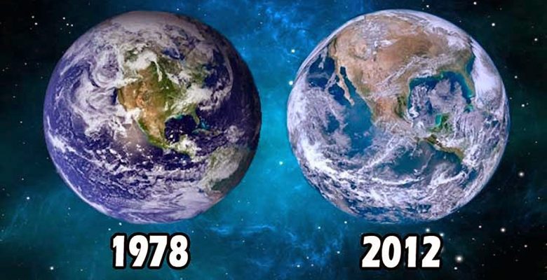
It seems NASA can not make up their minds what the globe earth should look like. Check the radically different sizes of the United States on the globe earth in these two official NASA “photographs”. One taken in 1978 and the other in 2012. During that time somehow the United States has grown enormously and in 2012 takes up almost twice as much space on the globe than it did in 1978? This is not possible of course. It means either one or both of these NASA “photos” are fakes.
NASA is doing a great disservice to the world in presenting composite Photoshoped images as being actual photographs of the earth from space.
Why not just take honest photos and provide us with the raw unprocessed unenhanced images?
I get your point, and the 2012 one isn’t real, but there was no photoshop in 1978. So why do you still beleive in the flat earth again? I know earth didn’t majicaly turn into a disc. Explain the phisics of that.
Photoshop is a painting program. It just computerizes the airbrushes and paints they had before photoshop was invented… So it is not that before Photoshop was invented they could not paint….
Photoshop not around in 1978? I have direct intel that the technology we are using right now “2021” is 70 years old.
Photoshop is just automated photo editing. They had photo editing in 1978 but it was done with a different technology. Have you heard of paint brushes? Photoshop has got digital paintbrushes. But in 1978 they actually used to have real paintbrushes.
Please share your Intel with us. I can assure you that computer image processing was still in its infancy less than 40 years ago. I worked with one of the first (still primitive) systems in the Netherlands.
Yes. Before NASA used paint brushes and air brushes to fake their images, now they use Photoshop. But it not that NASA were unable to fake things before Photoshop. They had so many great technologies back in the 60’s and 70’s to fake things, even though they did not have Photoshop yet…
Hahha yeah no photoshop but they went to the moon
So you can’t go to the moon without Photoshop?
The point is if NASA really went to the moon they would have had unlimited opportunities to take real photos of their globe earth. They would have no need to fake photos of their globe earth using Photoshop. But NASA openly admit they do use Photoshop to fake “photos” of the globe earth. Means they don’t have real photos of their globe earth to show us.
The old photo is taken from a far away distance by a geostationary or maybe Apollo mission.
The right side photo is taken by a low earth orbit satellite. As it is very near to earth, it can only see a small part of the sphere at a time. These pics are then combined to make the full pic.
One can do it himself that of camera is very near to the object, the markings or any shape on that object will look to be huge.
I had the exact same conversation from vedic flat earth community guy. He agreed to my point when we both did the experiment ourselves.
Honestly do you think they can make such “mistake”. It looks odd to everyone that USA is so big compared to earth surface which we are seeing.
This is just geometry working and we humans are used to watching things from far away.
Yes old news, nasa always says its fake because it has to be. Just like part real rockets part models on the old 80s shuttle missions,…looked very phoney especially when they encountered that giant in space. But again they always show this stuff , the attitude is that if you re too dumb to see the truth you deserve to be misled.
NASA is faking everything. That explains all the anomalies you find
It’s kinda like all the NASA moon shots of them supposedly walking on the moon, they are always close to the edge, close enough to walk off of it??? It doesn’t make sense? why they would land so close to the edge, every, single, time, well 6 times apparently? Why not land in the middle?
The issue, AS ALWAYS with you people is that you’re really, really not capable of spatial reasoning. The Earth is MUCH LARGER than you realize. That’s why you dont understand why theres a difference between 2 composite images from satellites, and also why you repeatedly fail to understand why ‘”the horizon always rises to your eyes when you go up in altitude”. If you understood the SCALE of the Earth , especialy compared to a human, you would understand that the Earth shouldnt “fall away quickly” as you rise in PUNY AMOUNTS OF ALTITUDE THAT PALE IN COMPARISON TO THE TOTAL CIRCUMFERENCE OF THE EARTH, because it is much, much larger and much gentler a curvature than you understand..
The same goes for your failed criticism of these images. You consistently fail to understand the scale, and also you fail to understand that YOUR EYES CAN DECIEVE YOU.
Hi Cwood. The images are fake, photoshop compositions, even according to NASA? The only actual photo, taken as a single exposure from a camera, NASA really claim to have is the famous “Blue Marble” “photograph”, taken from Apollo 17:
https://www.nasa.gov/content/blue-marble-image-of-the-earth-from-apollo-17
However, knowing that the Apollo missions never left low-earth orbit, and therefore could never have taken a photo like this, its true origins are a mystery. Conceivably NASA might have taken it from an unmanned craft but in those days there was no way of broadcasting back the high-resolution image, so they would have had to land and find it and process the film negative, highly unlikely.
Most likely source would have been a NASA artist’s painting.
If you disagree then please present the actual real photographs of the earth from space presented by NASA that are the result of a single camera exposure, not a composition of images from various sources manipulated in Photoshop.
👍😏
I am a bit disappointed that you haven’t responded to Abhinav’s comment. Take a globe, let’s say 30 cm wide. Take a picture, 10 cm away (comparable with a bit more than low Earth orbit) 30 cm away, 60 cm away, 90 cm away (comparable with geostationary orbit). Look at the differences. Look at how big the USA looks in the first picture.
It really is a simple matter of distance.
Rubbish. If you can see the whole globe earth and take a picture of the globe the continents always have to be the same size. But not for NASA. They provide us with “photos” of the globe earth but their continents are vastly different sizes. Means NASA’s “photos” of the globe earth, or at least some of them, are faked.
Do the experiment!
https://www.quora.com/Why-is-the-picture-of-the-Earth-in-10-years-too-different
I don’t know what is your point? In the link you provide they admit NASA’s “photos” of earth are not real photos, rather they are satellite imagery pasted on a globe. So they are NOT photos of the earth taken from space. That is the point. The only photo of earth taken from space that NASA regularly present as a “real” photo is the Blue Marble, and that also has been discredited.
s